S34I is an innovative European project that seeks to increase Europe’s autonomy in raw materials resources by utilising advanced data-driven techniques for analysing Earth observation (EO) data.
The backbone of Europe’s economy lies in its raw materials. They provide a robust industrial foundation, producing a diverse range of goods and applications that are a part of our daily lives and modern technologies. However, the availability of certain raw materials remains a growing concern both within the EU and throughout the world. It’s essential to ensure reliable and unrestricted access to these materials to maintain a stable and flourishing economy.
European raw materials are crucial
Europe has always been dependent on other regions for its raw materials, which makes it vulnerable. However, a new project called S34I, which was launched in January 2023 and co-ordinated by the University of Oporto, aims to increase Europe’s autonomy in raw materials resources by utilising advanced data-driven techniques for analysing Earth Observation (EO) data.
The project leverages Copernicus and other satellite sensors (including optical and radar) for data collection, while other platforms like airborne, low altitude platforms, ground-based, in-situ techniques/methods, and fieldwork are used to complement Copernicus data or for calibration and validation purposes. The S34I project’s primary focus is on systematically exploring minerals and continually monitoring extraction, closure, and post-closure activities to improve European knowledge and autonomy on raw materials resources. Additionally, the project seeks to improve social acceptance of mining (SLO) and promote better legislation.
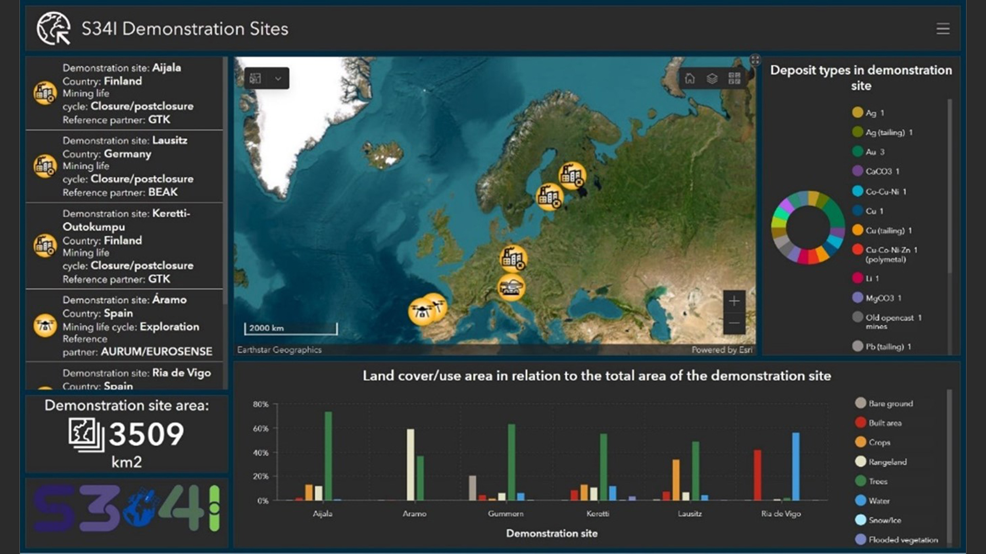
S34I is developing technical experiments and pilot validations/demonstrations for six pilot use cases, including Onshore Exploration, Shallow Water Exploration, Extraction, and Closure/Post-Closure:
Onshore Exploration (Áramo, Spain): Using artificial intelligence (AI)techniques like support vector machine (SVM), random forest (RF), and artificial neural networks (ANN), the project aims to map potential Cobalt (Co) target areas using various satellite-based datasets. This includes leveraging self-organising maps (SOM) for preprocessing exploration datasets and combining geological and remote sensing models to detect hydrothermal alterations associated with Co.
Shallow Water Exploration (Ria de Vigo, Spain): AI/ML techniques are utilised to post-process UHI data to establish a spectral library for ground-truthing and correlate it with onshore EO data. Geological studies help in identifying promising areas for placer deposit occurrences.
Extraction (Gummern, Austria): The project aims to improve volume mapping of mining waste deposits and monitor ground instability using techniques like Structure from Motion (SfM) photogrammetry and InSAR methods, respectively. Additionally, mineral stockpile volume estimation is performed using satellite photogrammetry and 3D-stereo images.
Closure/Post-Closure (Lausitz, Germany and Keretti-Outokumpu, Finland): Advanced AI techniques such as SBAS-InSAR and predictive modelling are employed for ground instability mapping and Acid Mine Drainage (AMD) prediction.
Earth observation data is key
The project’s methodology involves conducting multi-scale and multi-platform analysis of EO data, which is harmonised to meet EU data quality standards. Prototype processing pipelines are currently under development for three service categories: mapping raw materials deposits, providing early warnings for risk reduction, and monitoring environmental changes.
S34I uses advanced AI techniques, such as SBAS-InSAR and predictive modelling, to create a comprehensive view of ground instability mapping and Acid Mine Drainage (AMD) prediction. The project is also paying special attention to enhancing geological integration at the land-sea interface and ensuring open access to research datasets.
Ultimately, the project aims to demonstrate the value of its results to stakeholders by promoting secure and sustainable raw materials supply to Europe while enhancing resilience and reducing dependence on non-EU sources.
S34I is the perfect example of how innovation and technology can help boost Europe’s self-reliance and ensure that it remains a leader in raw materials resources.
Please note, this article will also appear in the 18th edition of our quarterly publication.
The UK Space Agency has announced its largest investment into an early-stage technology programme to improve the UK’s Earth observation technologies.
Delivered by the Centre for Earth Observation Instrumentation (CEOI), the £9m will support 12 projects that will monitor Earth’s atmosphere and measure critical emissions.
This doubles the programme’s previous largest funding round.
The new technologies, with their potential to provide a clearer picture of high-emission activities and incidents, offer a beacon of hope in our fight against climate change.
They could enable decision-makers to coordinate more effective responses, marking a significant step forward in our efforts.
Andrew Griffith MP, Minister for Space at the Department for Science, Innovation and Technology, said: “This exciting new generation of satellite instruments, backed by £9m in government funding, will play a key part in our efforts to tackle climate change, pinpointing where emissions are highest on our planet and cementing UK leadership in Earth observation, while helping to attract more private investment into this fast-growing sector.”
The funding will be bolstered with an additional £2m from the academic and private sectors.
The UK is a world leader in Earth observation
The UK has pledged £314m to Earth observation as part of a record £1.8bn investment in the European Space Agency.
Last month, two UK projects were shortlisted by ESA in the latest round of its Earth Explorers programme, dedicated to backing the most innovative satellite missions that monitor the environment.
One of the projects that received funding was Hydroterra+, which would be placed in geostationary orbit to give data twice a day on water cycles and tectonic events over Europe, the Mediterranean and North Africa, and Keystone.
The satellite would provide the first direct observations of atomic oxygen at 50 to 150km altitude. The project will allow scientists to examine the impact of solar cycles and space weather on certain regions of the atmosphere.
CEOI projects
The projects set to include CEOI funding are:
CITISCAN Payload Development (£1.15m) – Thales-Alenia Space UK with support from the University of Leicester
Cold Atom Interferometry Thermosphere Drag Measurement (CAITDM) (£1m) – STFC-RAL with support from the University of Nottingham and Metamorphic Additive Manufacturing Ltd
SOLSTICE: Solar Occultation Limb Sounding Transformative Instruments for Climate Exploration (£2.3m) – STFC-RAL with support from Bright Ascension and Open Cosmos
Prototyping an unfolding space telescope for a small satellite platform (£900,000) – Super-Sharp Space Systems with support from In-Space Missions Ltd
The Near Infrared Multispectral Camera for Atmospheric Methane (NIMCAM): Instrument demonstration and space mission development (£1.7m) – the University of Edinburgh with support from STFC-UKATC (UK Astronomy Technology Centre), NPL (National Physical Laboratory)
Hyperspectral Chroma-D Instrument (HERCHI) Payload Development (£900,000) – Surrey Satellite Technology Ltd, with support from Pixalytics Ltd
Expanding GNSS-R for HydroGNSS Constellation (£250,000) – Surrey Satellite Technology Ltd with support from the University of Nottingham and National Oceanography Centre, Southampton
Umbrella Radiation Monitor: Phase 2 Demonstration Model Development (£250,000) – Umbrella Space Science Ltd with support from BGHTECH Ltd and Leese SPM Ltd
5 THz Receiver Breadboard for Upper Atmosphere Science (£250,000) – STFC RAL Space with support from the University of Leeds
Evaluation of Novel Design for reduced dark current in VLWIR MCT arrays (£67,000) – Leonardo UK
EO-APU: Prototype Development for an AI-Driven EO Processing Unit (£75,000) – Surrey AI Imaging Ltd with support from Blue Sky Imaging Ltd
High-accuracy Magnetometer for Space Weather Instrumentation (HMSWI) (£65,000) – STFC RAL Space with support from the British Geological Survey (BGS), University of Strathclyde and Iota Technology Ltd
RSS-Hydro discusses a prospective all-in-space solution that leverages high-resolution satellites to revolutionise disaster response and enhance global security for a more resilient future.
The Earth, a vibrant tapestry woven from diverse ecosystems, faces a growing threat from natural disasters.
From the fury of hurricanes and tsunamis, to the silent creep of droughts, and the destructive force of wildfires, these disasters disrupt lives, displace communities, and inflict massive economic damage.
While existing Earth Observation (EO) satellites offer valuable insights, their effectiveness is hampered by a silent enemy – latency.
The time it takes to process data and deliver actionable information to those on the ground can be the difference between a well-co-ordinated response and a desperate scramble for resources. This delay can prove catastrophic in critical situations, hindering rescue efforts, jeopardising lives, and amplifying the overall impact of the disaster.
Closing the latency gap: A high-tech network in space
Now, with all possible space technology, we could start thinking about an innovative all-in-space solution that tackles latency head-on by creating a comprehensive network of satellites orbiting Earth; a constellation of satellites around the planet, constantly gathering information.
These satellites are equipped with advanced sensors capable of capturing high-frequency, multispectral imagery, at high spatial resolution.
Unlike traditional single satellite missions, this approach creates a detailed picture of the situation below by capturing data across multiple spectrums. Imagine the ability to not only see flooded areas in high resolution but also to identify the depth and potential flow patterns based on radar and thermal data.
Additionally, radar sensors can penetrate cloud cover and debris, providing vital information during storms or landslides. This comprehensive data collection empowers near-real-time data acquisition – even in remote areas with limited infrastructure on the ground.
This constant stream of new or updated information information empowers a faster response, minimising the window of opportunity for disaster to wreak havoc.
Furthermore, the constellation design ensures frequent overpasses, increasing the likelihood of capturing critical data at the precise moment it’s needed.
Thinking outside the box: Onboard satellite processing
The all-in-space solution’s brilliance extends beyond data collection. It breaks new ground by performing initial processing and analysis directly onboard the satellites,1,2 effectively transforming them into mini-analysis centres in space. This concept, known as ‘onboard satellite constellation processing,’ eliminates the latency associated with transmitting raw data back to Earth for processing.
Consequently, the system can extract critical information and identify areas of concern much faster, providing decision-makers with near-real-time insights.
Imagine receiving immediate alerts about flood zones, wildfire trajectories, or potential landslides, accompanied by critical data points like estimated water depth or predicted fire spread. This empowers rapid mobilisation of resources, potentially saving lives and minimising property damage.
Additionally, onboard processing reduces the overall data volume that needs to be transmitted back to Earth, alleviating bandwidth limitations and further reducing latency.
Unlocking the secrets of big data: Space age supercomputers
The journey doesn’t end with onboard processing. The all-in-space solution could utilise powerful ‘orbital compute nodes’ – essentially supercomputers orbiting Earth. These nodes leverage cutting-edge machine learning algorithms to unlock the true potential of the vast amounts of EO data acquired by the satellites.
Picture these nodes as analytical powerhouses in space, sifting through mountains of data and uncovering hidden patterns. This allows for a deeper understanding of the situation on the ground, leading to targeted responses that minimise damage and save lives.
For example, the system could analyse historical fire data and weather patterns to predict the path of a wildfire with greater accuracy, allowing for targeted firebreaks and evacuations.
Additionally, by analysing historical flood data and terrain information, the system could identify areas at higher risk of landslides or more flooding, enabling preventative measures to be taken.
Seamless delivery: Putting information in the right hands
The solution doesn’t stop at analysis. Advanced data transmission protocols and secure communication networks ensure critical information reaches those who need it most.
Imagine a secure network delivering high-resolution images, flood maps, near real-time fire perimeters, and even potential landslide risk zones directly to the devices of disaster response teams. This empowers them to make informed decisions in the field and mobilise resources quickly and efficiently, saving lives.
A search and rescue team could co-ordinate their efforts based on real-time data on flooded areas and potential survivors trapped in debris. These secure networks could also be integrated with existing communication infrastructure, ensuring that critical information reaches not only disaster response personnel but also government agencies, humanitarian organisations, and even local communities.
This widespread dissemination of information fosters a collaborative approach to disaster response, maximising efforts and minimising losses.
Beyond disaster response: A broader impact for a safer world
The application of this technology extends far beyond flood mapping. This real-time, multi-sensor approach holds immense value for a wide range of civil security applications, such as real-time wildfire and deforestation monitoring, allowing for quicker intervention and environmental protection.
Early detection of forest fires, for example, can significantly reduce ecological damage and potential loss of biodiversity. Tracking illegal activity at sea or monitoring critical infrastructure can be significantly enhanced with constant surveillance from space.
This technology has the potential to revolutionise several critical areas:
Combating illegal activities
Illegal activities at sea, such as illegal fishing or human trafficking, could be significantly hampered. The ability to track vessels in real-time using a combination of optical and radar data would empower coast guards and law enforcement agencies to identify and intercept suspicious activity. This could significantly reduce illegal fishing practices, protecting marine ecosystems and ensuring sustainable fisheries.
Additionally, real-time monitoring of shipping lanes could be used to identify potential piracy threats, enhancing maritime security.
In fact, a number of new space companies and non-profit organisations are already developing services that use this type of technology in the marine surveillance sector.3, 4
Protecting critical infrastructure
Critical infrastructure, like pipelines, dams, and power grids, is vital for modern societies. This technology can be used to monitor these structures for potential hazards, allowing for preventative measures to be taken and potential disasters to be averted.
For example, high-resolution radar imagery can detect subtle changes in ground deformation, potentially indicating an impending landslide that could threaten a vital pipeline. Thermal data could be used to identify hotspots along power lines, allowing for targeted maintenance and preventing widespread outages.
Enhancing environmental monitoring
The real-time, multi-sensor data collected by this system can be invaluable for environmental monitoring efforts. Imagine being able to track deforestation activities in real-time, allowing for quicker intervention and stricter enforcement of environmental regulations.
Additionally, the system could be used to monitor natural resources like water levels in critical aquifers or track the health of coral reefs, providing valuable data for conservation efforts.
Promoting global security
The ability to monitor activity on a worldwide scale, particularly in remote or sensitive regions, has significant implications for international security. This technology could be used to track the movement of troops or military equipment, potentially deterring aggression and promoting peaceful conflict resolution.
Additionally, real-time monitoring of nuclear facilities could enhance international oversight and non-proliferation efforts.
The all-in-space-solution: Building a more resilient future
This all-in-space solution isn’t just about technology but ushering in a brighter tomorrow. By revolutionising disaster response, enhancing global security efforts, and promoting environmental sustainability, it has the potential to create a world where we are better prepared for emergencies, more proactive in protecting our planet, and more secure as a global community.
This innovative approach to an all-in-space solution is currently being actively explored by RSS-Hydro and its partners.
References
Mateo-Garcia, G., Veitch-Michaelis, J., Smith, L. et al. Towards global flood mapping onboard low cost satellites with machine learning. Sci Rep 11, 7249 (2021). https://doi.org/10.1038/s41598-021-86650-z
Nafiseh Ghasemi and Jon Alvarez Justo and Marco Celesti and Laurent Despoisse and Jens Nieke. Onboard Processing of Hyperspectral Imagery: Deep Learning Advancements, Methodologies, Challenges, and Emerging Trends. Image and Video Processing, eess.IV (2024). https://doi.org/10.48550/arXiv.2404.06526
Kroodsma, D.A., Hochberg, T., Davis, P.B. et al. Revealing the global longline fleet with satellite radar. Sci Rep 12, 21004 (2022). https://doi.org/10.1038/s41598-022-23688-7
Paolo, F.S., Kroodsma, D., Raynor, J. et al. Satellite mapping reveals extensive industrial activity at sea. Nature 625, 85–91 (2024). https://doi.org/10.1038/s41586-023-06825-8
Please note, this article will also appear in the 18th edition of our quarterly publication