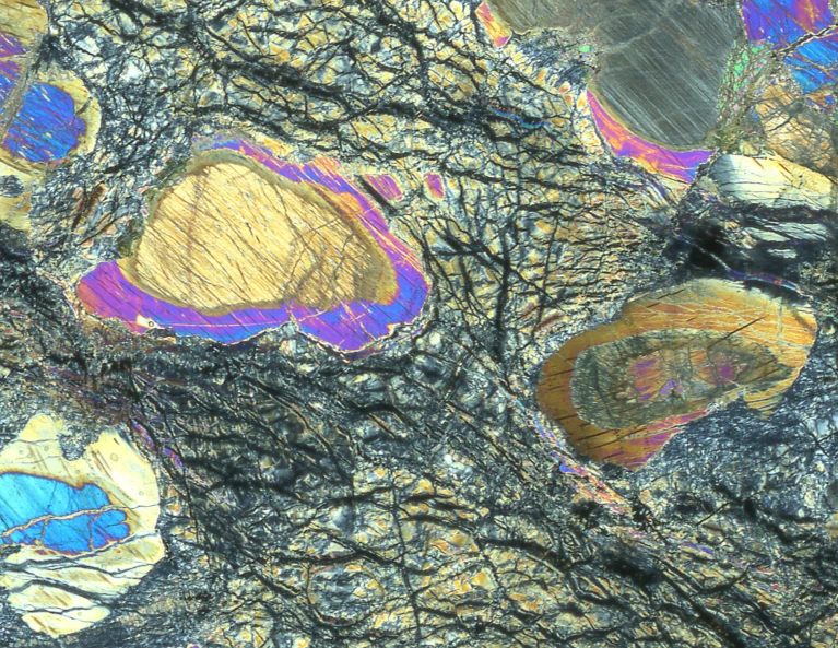
A sample of mantle rock viewed under a microscope.Credit: Johan Lissenberg
A record-breaking expedition to drill into rocks at the bottom of the Atlantic Ocean has given scientists their best glimpse yet of what the Earth might look like underneath its crust.
Researchers extracted an almost uninterrupted 1,268-metre long sample of green-marble-like rock from a region where Earth’s mantle — the thick, interior layer that makes up more than 80% of the planet’s bulk — has pushed up through the sea floor (see ‘Deep-sea drilling’). The samples, described on 8 August in Science1, offer unprecedented insights into processes that lead to the crust’s formation.
Ocean-drilling ship that revolutionized Earth science due to retire
“We had that story in our head” about what this kind of rock should look like, but it’s completely different when “you see it there on a table”, says Natsue Abe, a petrologist at the Japan Agency for Marine-Earth Science and Technology in Yokohama.
The expedition’s achievements are a “fantastic landmark”, says Rosalind Coggon, a marine geologist at the University of Southampton, UK. “Ocean drilling provides the only access to samples of Earth’s deep interior that are key to understanding our planet’s formation and evolution.”
Geoscientists worry that it will be a long time until they can follow up with more studies, because the decade-long International Ocean Discovery Program (IODP) is coming to an end, and the United States is retiring its workhorse research ship, JOIDES Resolution.
Researchers examine rock cores retrieved during an ocean-drilling expedition.Credit: Erick Bravo, IODP JRSO (CC BY 4.0)
Oceanic crust — the type of crust found mainly underneath Earth’s seas, rather than its continents — is mostly made up of dense, volcanic rock called basalt. It is much thinner and younger than continental crust, because the rocks are recycled continually by the movements of tectonic plates.
Basalt forms when magma pushes up through undersea cracks along formations called mid-oceanic ridges. The magma itself originates from a process called partial melting in the mantle — which is largely made up of translucent-green, magnesium-rich minerals. As material in the mantle rises, the pressure over it drops, which causes some of these minerals to melt and form microscopic films of magma between rock crystals.
Usually, only magma erupts onto the sea floor. But at some sites, mantle rock also makes it to the surface, where it interacts with sea water in a reaction called serpentinization. This alters the rock’s structure — giving it a marble-like appearance — and releases various substances, including hydrogen.
Easy to drill
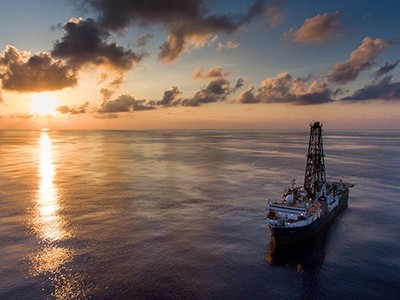
In May 2023, JOIDES Resolution was visiting a site where this has happened: an undersea mountain called the Atlantis Massif, located just west of the Atlantic’s mid-ocean ridge. The 143-metre-long ship is equipped with a 62-metre-tall crane for undersea drilling.
The researchers on board chose to drill at Lost City, a site on the southern side of the massif. The region is punctuated with hydrothermal vents where extremophile microorganisms feed on the hydrogen that seeps out.
“We had only planned to drill for 200 metres, because that was the deepest people had ever managed to drill in mantle rock,” says Johan Lissenberg, a petrologist at Cardiff University, UK. But the drilling was surprisingly easy and three times faster than usual, returning long, unbroken cylinders of rock called cores. “So, we just decided to keep going,” says Lissenberg. The team stopped only when the expedition was coming to its scheduled end.
The researchers have now published their initial findings. “What we report is literally what you can do on the ship. A team of 30 scientists poring over the cores 24 hours a day for two months, and logging centimetre by centimetre as it’s coming up.”
When the scientists examined the structure of the rock in detail, they observed ‘oblique features’, a telltale signature of the prevailing theory of how magma separates from the mantle to become part of the crust, says Lissenberg. The mantle rock was also interspersed with other types of rock in the cores, suggesting that the mantle–crust boundary is not as sharp as seismographic data normally suggest, says Jessica Warren, a geochemist at the University of Delaware in Newark. Together, these results “are key to how we understand the formation of tectonic plates in the oceans”, she says.
Uncertain future
The trip capped a worthy four-decade career for the JOIDES Resolution, which the US National Science Foundation (NSF) had been renting from a private company. But the NSF has announced that it can no longer afford the US$72 million per year that it costs to run the ship after it fulfilled its IODP obligations, and that the programme would be discontinued. This leaves some scientists, especially those at early career stages, uncertain about the future of the field, says Aled Evans, a marine geologist at the University of Southampton.
One remaining ‘grand challenge’ for geoscientists is to drill through the basaltic layer and across the boundary between crust and mantle — called the Mohorovičić discontinuity or ‘Moho’. This would allow them to access pristine mantle rock that hasn’t reacted with seawater. “We haven’t drilled into the real mantle yet,” says Abe. The unexpectedly smooth drilling at Lost City bodes well for those future attempts, which could be carried out by Japan’s research ship Chikyū, she adds. “Mantle rocks are the most common part of our entire planet,” says Evans. “Sampling them would tell us something fundamental about what our planet is made of.”
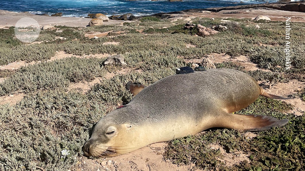
Scientists attached cameras and sensors to small pieces of neoprene that they glued to the sea lions’ backs.Credit: Nathan Angelakis
Footage captured by sea lions wearing lightweight video cameras is giving researchers a glimpse of previously unexplored areas of the sea floor off the south coast of Australia.
The findings, published on 7 August in Frontiers in Marine Science1, include detailed maps of the ocean floor created by combining videos captured by the animals with a machine-learning model. The camera footage also reveals details of how different habitats and species are distributed.
“These are particularly deep and remote offshore habitats that you can’t get to by usual surveys that you would conduct from a boat,” says co-author Nathan Angelakis, who researches ecology and evolutionary biology at the South Australian Research and Development Institute in West Beach. “With the data we’re collecting, we’re essentially exploring new parts of the ocean that haven’t been mapped”.
Uncharted waters
Understanding the layout of the sea floor is important for several reasons, including marine conservation, navigation and predicting hazards such as tsunamis. “You can’t manage what you haven’t measured,” says Steve Hall, head of partnerships at the ocean-mapping organization Seabed2030, which is based in Liverpool, UK.
This AI learnt language by seeing the world through a baby’s eyes
Worldwide, just 26% of the sea bed has been mapped at high resolution. This is partly due to the challenges associated with exploring the deep sea, where pressure is extremely high and light levels are low. Researchers typically map the sea bed using remote-operated underwater vehicles or by dropping cameras from surface vessels — but both of these methods are time-consuming and costly.
Angelakis and his colleagues trialled a comparatively low-tech approach by enlisting the help of wild Australian sea lions (Neophoca cinerea). These animals spend most of their time on the sea bed, foraging for food across the continental shelf, the section of the ocean that extends from the coastline. The researchers theorized that by tracking the sea lions’ movements, they would be able to gather information about both the shape of the sea floor and the distribution of different habitats.
The authors attached sensors to neoprene patches that they glued to the backs of eight adult females from two of the largest Australian sea-lion colonies. The equipment, which included GPS trackers, cameras and motion sensors, was designed to be small and non-cumbersome, weighing less than 1% of the sea lions’ body weight, so as not to hinder the animals or affect their behaviour. On completion of the project, team members were able to remove the sensors from the patches without damaging the sea lions’ fur.
Together, the sea lions captured 89 hours of footage that took in six distinct sea-floor habitats, from bare sand to meadows of algae.
The researchers used the footage to assess biodiversity in these areas, and to compare the locations visited by the two colonies. They also used the videos to check the accuracy of a machine-learning model designed to predict the sea-floor habitat from variables such as sea-surface temperature and distance from the coast. This revealed that the model was more than 98% accurate, so the researchers then used it to map sea-floor habitats in surrounding locations. “One of the real powers of the study is taking the data we collected to predict other unknown areas,” says Angelakis.
The team also wants to use the sensor data to explore how factors such as depth and nutrient supply affect habitat distribution and biodiversity on the sea floor. This could help researchers to further explore “the ecological value of different habitats and marine areas to sea lions”, says Angelakis, which could boost conservation efforts.
Using sea-lion-mounted sensors is a “very nice way of getting high-resolution data from a hard-to-get-at place”, says Hall. He suggests that in future studies the researchers could equip the sea lions with extra sensors to gather data on the physical and chemical properties of sea-bed habitats.
A study reveals that, unexpectedly, plants display a greater diversity of traits in drier environments. Trait diversity is a measure of an organism’s performance in an environment and can include things like the size of a plant or its photosynthetic rate. Although there are good data on this kind of diversity in temperate regions, an assessment of drylands has been lacking. The new study fills this knowledge gap and finds that, counter to a prevailing expectation that fewer traits would be displayed, at a certain level of aridity, trait diversity doubles. The team behind the work hope that it can help us better protect biodiversity as the planet warms and areas become drier.
Research Article: Gross et al.
08:25 Research Highlights
Butterflies and moths use static charge to pick up pollen, and quantum physics rules out black holes made of light.
Research Highlight: Charged-up butterflies draw pollen through the air
Research Highlight: Black holes made from light? Impossible, say physicists
10:59 The Great Barrier Reef is the hottest it’s been for centuries
An assessment of coral skeletons has shown that the past decade has been the warmest for the Great Barrier Reef for 400 years. By looking at the chemical composition of particularly old specimens of coral in the reef, researchers were able to create a record of temperatures going back to 1618. In addition to showing recent record-breaking temperatures, they also developed a model that suggests that such temperatures are very unlikely to occur without human-induced climate change. Altogether, the study suggests that the reef is in dire straits and much of the worlds’ coral could be lost.
Research Article: Henley et al.
News and Views: Coral giants sound the alarm for the Great Barrier Reef
Nature News: Great Barrier Reef’s temperature soars to 400-year high
18:56 ‘Publish or Perish’ becomes a card game
Most researchers are familiar with the refrain ‘Publish or Perish’ — the idea that publications are the core currency of a scientist’s career — but now that can be played out for laughs in a new board game. Created as a way to help researchers “bond over shared trauma”, the game features many mishaps familiar to academics, scrambles for funding and scathing comments, all while players must compete to get the most citations on their publications. Reporter Max Kozlov set out to avoid perishing and published his way to a story about the game for the Nature Podcast.
Nature News: ‘Publish or Perish’ is now a card game — not just an academic’s life
Subscribe to Nature Briefing, an unmissable daily round-up of science news, opinion and analysis free in your inbox every weekday.
Palaeoceanographic proxy data and climate-model simulations reveal that during the last ice age — about 20,000 years ago — the Gulf Stream was much stronger than it is now because of more-powerful winds across the subtropical North Atlantic Ocean.
Corals frying in Florida, billions of snow crabs dead in the Arctic — climate change is wreaking havoc in the world’s oceans1,2. The race is on to protect marine areas amounting to 30% of global seas by 2030 under the Convention on Biological Diversity. Controlling uses of the high seas — waters that are beyond national control, comprising around two-thirds of the surface area of the planet’s oceans — is crucial, because there is currently no international policy mechanism for biodiversity conservation in these areas.
That is set to change in the next year, following the adoption in June 2023 of the High Seas Treaty, a new agreement that forms part of the United Nations Convention on the Law of the Sea. When it enters into force — probably in 2025, after 60 nations have ratified it — the treaty will enable implementation of new marine conservation tools in parts of the ocean that are beyond national jurisdictions. The treaty provides new tools that will help protect the high seas from human industrial activities. Broadly, it recognizes climate change as a threat to the success of these measures. But specific actions remain to be taken to mitigate that threat3.
The pace and scale of climate change raises questions about how best to define areas of marine protection4. In particular, how can species that move be conserved as their distributions change because of warming waters? Tunas cross the Pacific Ocean to breed and hunt. Whales migrate from polar regions to the subtropics to feed and give birth. As water temperatures and ocean currents change, so too will these routes and timings. Other climate-change effects, including ocean acidification and disruptions to food webs, could accentuate species shifts.
For instance, North Atlantic right whales (Eubalaena glacialis) have altered their migrations, moving farther north and into new regions off the coast of Canada in response to warming waters and changes in food availability5. There, these endangered animals have come into additional conflict with fisheries and shipping, resulting in deaths. Consequently, new conservation measures are needed in the areas into which the whales are moving, in addition to those in their original habitats.
Protecting biodiversity in the high seas in the face of climate change is an ongoing chess game. Coordination across jurisdictions — including national and international boundaries and the high seas — will be crucial. Strategic planning at a global scale will be needed3. It will require a mix of conservation areas that serve as reference points and others to be placed in anticipation of climate-related changes.
As nations gather at the first preparatory meeting on implementing the High Seas Treaty this month in New York City, we share here our experiences of working on such issues in the North Atlantic. We propose three steps that will allow the High Seas Treaty to address climate-change impacts on species effectively: collaborating across sectors; simulating movements of species and developing strategic plans for conservation; and building capacity and mechanisms in the treaty for implementing dynamic marine protections.
Learn from the North Atlantic
The North Atlantic hosts globally important ocean currents, including the Gulf Stream, which moves warm subtropical waters northwards, and the Labrador Current, which moves cold waters southwards around Greenland and down the eastern coast of Canada. These currents and the nutrients they carry meet in a complex whirl of eddies, forming an area of tremendous productivity that is important to wildlife and the source of one of the world’s most productive cod and lobster fisheries.
Governance of these rich fishing grounds and their conservation areas are equally complex. As well as spanning Canadian waters, areas crossed by these two currents come under the jurisdiction of the Northwest Atlantic Fisheries Organization (NAFO). The currents also influence an area governed by the Oslo–Paris Convention for the Protection of the Marine Environment of the North-East Atlantic (OSPAR) and by the North-East Atlantic Fisheries Commission, among others.
Canadian conservation measures include closures that prevent fishing methods that come into contact with the sea bottom, and marine protected areas that can cover the full water column. In an adjacent patch, NAFO maintains bottom-fishing closures to protect vulnerable marine ecosystems, including concentrations of deep-water corals and sponges. To the east, OSPAR has designated a marine protected area to conserve seabirds, whales and seafloor ecosystems (called the North Atlantic Current and Evlanov Sea Basin Marine Protected Area, or NACES; see ‘Species on the move’)6.
L. Hannah et al. Sources: Ranges: aquamaps.org; thick-billed murre data: A. Patterson et al. Marine Ecology Progress Series MEPS-2023-10-023 (in review).
None of these conservation measures can be fully effective in isolation. Regional ecosystems are interconnected — seabirds that nest in Canada fly out to feed south of Greenland when nesting is finished; whales use the entire region; and the rich invertebrate sea-bed communities of the Flemish Cap, an isolated bank some 500 kilometres east of Newfoundland are likely to be genetically connected to the sea floor communities of the NACES Evlanov Seamount.
Climate change will broaden these connections, with species potentially entering Canadian waters from the northeast on the Labrador Current. The changing strengths and interactions of currents will profoundly reorganize species’ distributions and affect fisheries, requiring even greater coordination of management across the region.
Dumping, pillaging and slavery — why exploitation of the high seas must end
OSPAR has started to address these shifts by planning an ecologically coherent network of marine protected areas from south of Greenland eastwards to European national waters. This network is designed to protect all species that are endemic to the area, as well as representing other native species multiple times. This aims to insure against catastrophic loss of populations to disease, marine heatwaves or other events. None of these protections is formally coordinated with Canada or NAFO.
More cross-jurisdictional approaches will be needed. But, without an impetus, these could take decades. For example, OSPAR’s plans for NACES took around five years to develop, from the first proposal of the marine protected area in 2016 to its final approval in 2021. With climate change accelerating, the High Seas Treaty cannot wait so long. It needs to streamline the process for designating marine protected areas and put in place a strategy for a changing future. It can make a start through these three steps.
Coordinate among existing science and governance bodies
Many of the bodies for fisheries management, science and governance are central partners to the treaty and are already trying to incorporate climate change into their plans. Coordination of existing data and trends and effective communication of this information will allow for efficient management responses, which can then be integrated into more-comprehensive regional plans as the treaty comes into force. One practical step that could be taken immediately would be to start providing collated information on movements of seabirds and whales that can help shipping companies to minimize ship strikes and fisheries bodies to reduce the impacts on non-target species.
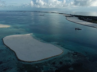
The Maldives is racing to create new land. Why are so many people concerned?
Examples of bodies working in this space include NAFO, OSPAR, the International Commission for the Conservation of Atlantic Tunas and the Western and Central Pacific Fisheries Commission. The Inter-American Tropical Tuna Commission and partners have developed a toolkit to provide scientific advice on shifts in species ranges related to fishing activity. The International Council for the Exploration of the Sea, which engages a network of 700 marine institutes across 20 member countries, is increasingly addressing climate-related impacts on marine species, fisheries and conservation areas in the Arctic, Atlantic and Mediterranean. These organizations, and others, need to accelerate and coordinate their efforts in anticipation of the Treaty coming into force.
Create regional climate conservation plans
Systematic plans for managing conservation across the high seas and national waters need to be developed. These can build on existing measures and knowledge of climate impacts on marine species. The High Seas Treaty includes provision for a science and technical body to advise its secretariat. Species movements and changing oceanographic dynamics due to climate change should be a key focus for that advisory body.
Scientists and managers should ensure that habitats and ecosystems are represented across multiple sites, to promote resilience in the face of climate change. And they should consider ‘whole ocean networks’ that capture the scale of species movements and population dynamics7.
Scientists and conservationists can start now by using computer modelling to simulate species shifts. On the basis of these results, together with understanding of key biodiversity areas and existing protections in national waters8, they can propose priorities for high-seas conservation.
Thick-billed murre, among other seabirds, are sensitive to changes in temperature and sea ice.Credit: Jenny E. Ross/Nature Picture Library
Conservation plans incorporating climate change have been completed for several ocean regions9, including OSPAR, which can act as an exemplar. Frontiers include considering extreme events such as marine heatwaves, as well as planning for species movements in three dimensions — latitude, longitude and depth10.
Researchers should adopt a ‘reference, core and flexible’ approach to marine protection plans11. This involves three key steps. First, establish a core set of fully protected areas, with protections extending throughout the water column. These can serve as reference points to understand how biodiversity responds to climate change in the absence of complex human uses such as fishing. Second, design a complementary system of fixed conservation areas that represent key habitats and species, using current areas and simulated future ranges. Third, supplement the network of core areas with extra measures that are flexible in time and space to account for unexpected species movements, new data and improved climate models.
Australia’s Great Barrier Reef is ‘transforming’ because of repeated coral bleaching
For example, in Canada, the St. Anns Bank Marine Protected Area provides a permanent core element that protects a key migratory pathway for many whale species. Across a wider region, lobster and crab fishing closures to prevent entanglement go into effect when whales are detected in an area, providing a more flexible element tailored for North Atlantic right whales.
Similar systems can now be planned across national waters and the high seas, for species whose ranges often cross jurisdictional boundaries and will move as a result of climate change. For example, some fish species are likely to shift with surface currents, which will affect where fisheries are located and which species are represented in conservation areas12. Recent proposals13 to trade commitments between nations for meeting the goal of protecting 30% of the world’s oceans by 2030 hinge on biodiversity targets that are verifiable across boundaries, further emphasizing the importance of systematic conservation planning for climate change. Done well, systematic planning can minimize costs while efficiently conserving moving species and ecosystems and benefiting fisheries and other ocean users.
Set up governance mechanisms and build capacity
Countries and other invited parties can begin to develop such strategies at the series of preparatory meetings that will take place in the run-up to ratification. At the first preparatory meeting this month, treaty planners can start to develop structures and procedures for planning conservation under climate change. They can mandate the treaty’s science and technical body to address climate change and foster regional climate conservation plans. Mechanisms for addressing species shifts and interactions with other governance entities will also need to be proposed, debated and approved by the ratifying countries, with support from non-governmental organizations and scientists.
With the arrival of El Niño, prepare for stronger marine heatwaves
The treaty has a strong emphasis on capacity building. Developing equitable, shared scientific understanding of how species shift their ranges under climate change is imperative to ensure that conservation measures under the treaty are effective in the long term. Yet models that simulate species’ movements and ocean change are complex14, are based mostly in high-income countries and have varying degrees of availability.
For instance, models of range movements for all known marine species across dozens of future climate scenarios are now freely available online (for example, aquamaps.org). By contrast, regional ocean models that enable high-resolution simulations of physical changes, such as those in the North Atlantic, are region-specific and might be less readily available in low- or middle-income countries (see, for example, go.nature.com/3vu7qi8).
The High Seas Treaty includes a provision for a committee to promote capacity building and marine-technology transfer, supported by a fund to finance these activities. National research-funding agencies and foundations can provide extra finance and take key roles as partners to the treaty. For example, the Belmont Forum is a consortium of national research-funding agencies from various countries worldwide that builds multinational teams to address global environmental problems15.
As the number of countries ratifying the High Seas Treaty grows, there is still time to lay the groundwork before the agreement enters into force — but the clock is ticking. Planning for protection of the high seas is a one-time opportunity. Only by engaging in each of the three solutions we discuss will the treaty be enabled to stand the stark test of climate change.
Marine ecologist Isabelle Côté (second from left) and the Salty Science team light flares as they cross the finish line at the island of Antigua, winning the women’s division of the World’s Toughest Row competition.Credit: World’s Toughest Row
Working scientist profiles
This article is part of an occasional Nature series in which we profile scientists with unusual career histories or outside interests.
Isabelle Côté is not one to shirk a physical challenge. So when a former graduate student asked her to join a team rowing across the Atlantic Ocean to raise funds for charities supporting marine conservation, education and science, she responded with an emphatic yes.
A marine ecologist at Simon Fraser University (SFU) in Burnaby, Canada, who studies coral reefs, Côté and her teammates spent three years planning and preparing mentally, physically and logistically for the World’s Toughest Row, a 4,800-kilometre crossing from Spain’s Canary Islands, off the coast of northwestern Africa, to the eastern Caribbean island of Antigua, in Antigua and Barbuda. When the race began, it was a challenging departure into the unknown. But on 20 January this year, after 38 days, 18 hours and 56 minutes, the aptly named Salty Science team rowed across the finish line, clinching first place in the women’s division and seventh overall in the race.
Côté was enlisted by her former doctoral student Chantale Bégin, a marine biologist at the University of South Florida in Tampa. While on sabbatical in Antigua doing field work, and living on a sailing boat with her husband and young children, Bégin had watched the finish of the 2018 race. “This is insane,” she remembers thinking. Her former undergraduate student, Lauren Shea, working in Antigua for Seamester, a study-at-sea programme, saw the 2020 and 2021 finishes and vowed to do the race herself one day. Shea reached out to Bégin and Noelle Helder, a marine scientist at the University of Alaska Fairbanks, whom she had befriended in one of Bégin’s marine ecology courses, to see whether they’d be interested, too, and they said yes straight away.
The trio wanted to recruit another female marine scientist. Bégin hadn’t spoken to Côté for years, but knew the 61-year-old was a canoeist and kayaker, ultra-marathon runner and long-distance swimmer. “I knew she had the endurance,” says Bégin. With Côté’s thumbs-up, the team became four.
Early enthusiasm was the easy part. The hard work came next.
Preparation, perspiration, trepidation
For the first year of planning and preparation, Côté was swamped with work, being the chair of Simon Fraser University’s biology department. So Helder and Bégin laid the foundation, finding a boat, researching what gear and training they would need and setting up a team website and social-media accounts. In the World’s Toughest Row, teams compete to navigate and row an unpowered 8.5-metre rowing boat, unsupported, across the Atlantic. Race entry is expensive, as is buying a purpose-built, high-tech boat that is seaworthy and fully kitted out. So most teams fundraise, not only to cover race expenses but also for a cause.
From the beginning, “it was pretty clear to us that the ocean was going to be our cause”, says Côté, noting that the whole team works on, under or around the ocean, and also spends a lot of recreation time there. Bégin and Shea were accomplished sailors, but none of the team members rowed. They also had to master technology and navigational tools, and hone their physical and mental stamina.
The Salty Science team of four marine scientists sets out from La Gomera in Spain’s Canary Islands at the beginning of the race.Credit: World’s Toughest Row
With the team of four representing three academic generations, “Isabelle was like the academic grandma of the younger two”, says Bégin, who was conscious that the hierarchical history could become “a weird thing”. From the beginning, they were consciously collaborative; each had delegated roles. Côté’s was emergency first aid.
The team set three goals, in priority order: to finish safely, to remain friends throughout and to row as fast as they could, explains Shea. “If we needed to stop rowing to have a team chat or go for a swim together, even though that wasn’t the fastest option, that’s what we’d do.”
Geographically separated for the introductory training phase, each learnt to row independently. “Classical rowing in narrow boats teaches you technique, but ocean rowing is a different beast altogether,” says Côté. “The only way to get good at ocean rowing is to row on the ocean.”
Performance coach and former rower Cady Hart-Petterssen, based in Plainfield, Vermont, designed their fitness regime. It was a meticulous plan, including training through periods of sleep deprivation, something they would face while rowing shifts of three hours on, three hours off, around the clock.
To build psychological resilience and effective team dynamics, they hired sports psychology consultant Terri Schneider, based in Santa Cruz, California, who designed individual and team-building exercises. A big focus, Schneider explains, was on coping mechanisms for staying functional in the face of fear, stress, exhaustion and physical discomfort. And — when not battered by seasickness — they did.
Perseverance in rough seas
The first ten days after departing from La Gomera in the Canary islands were rough. The 10-metre waves were bigger than their boat, which at times seemed to be almost vertical. “It was just terrifying,” says Côté. “I thought I was gonna die several times.”
Then the wind died. “The damn trade winds didn’t come,” or blew in the wrong direction. “We called those the rowing-in-cement days,” says Côté, in reference to how difficult it was to make progress. After riding massive waves during the first week and a half, and reaching a peak speed of more than 17 knots (31.5 kilometres per hour), they slowed down at times, during their cement days, to only 1 or 2 knots.
Côté knew from doing ultra-marathons — runs of 50 kilometres or more that had taken her 8–10 hours — that she often started and finished strong, with a low point in the middle.
Isabelle Côté with a look of disbelief once back on land after 38 days, 18 hours and 56 minutes of rowing across the Atlantic ocean.Credit: World’s Toughest Row
“I’ve suffered from mild depression my entire life,” says Côté. And during the race, “I really struggled with it. It hit me right in the middle. But I was in this situation, unlike other big events I’ve done, where I could not quit. Nobody was going to come and take me off that boat. And the only thing I could do to get myself out of there was to row. So that’s what I did.
“I’m proud of the fact that despite rowing under a black cloud, I gave 100% every shift,” says Côté.
The small team, rowing its tiny boat across a vast, unforgiving ocean, was cheered on by a big team of supporters. Côté’s former doctoral student Nicola Smith, a marine ecologist at Concordia University in Montreal, Canada, was one of many sponsors following their progress virtually. “I wanted to be a small part of her big dream,” says Smith. Despite being a lot older than her teammates, Côté “can work equally as hard and still accomplish great things”, says Smith. “She has shown me that dreams don’t have an expiration date.”
Reflecting on the epic experience, Côté said that the journey had reinforced (with a hefty dose of fear) her enormous respect for the ocean and its incredible beauty. Nevertheless, “it made me realize I love the coast”, she laughs.
One big take-way for Côté is that “I have the mental and physical fortitude to take on really big challenges”, she says. “I still don’t consider myself an extraordinary person,” she adds, but “ordinary people can do extraordinary things.”
Quick-fire Q&A
How did you not fall overboard in rough seas?
We got wiped off our seats many times but we were tethered to the boat — a requirement of the race. When big waves struck, you ended up on the gunwale somewhere, and the oars hit you. I had so many bruises.
Was there a captain of your crew?
We were asked by race organizers to designate a skipper. We resisted. We were very democratic. We decided to make all big decisions together. It worked out fine. We didn’t actually need a captain.
Were the age differences in your team an issue?
The youngest team members are in their late twenties, the same age as my oldest daughter. So there could have been a mother–daughter dynamic. But I was the least experienced offshore, the most scared and got extremely seasick. They took care of me, supporting me in the same way I support my children. So the tables were turned. Which was interesting, at my age of 61, to be put in that situation. We didn’t have a big generation gap except when it came to music.
What was on the voyage playlist?
So much Taylor Swift. I mean, I like Taylor Swift — but this was Taylor Swift on repeat for days and days. A lot of the other music was eclectic groups I didn’t previously know existed. [Bégin compiled a playlist for the trip titled Offshore, consisting of 1,529 songs with some thematic selections, such as Gloria Gaynor’s ‘I Will Survive’, Wyclef Jean’s ‘We Trying to Stay Alive’ and Jack Johnson’s cover of ‘A Pirate Looks at Forty’.]
We also listened to a lot of Freakonomics and other podcasts about social, economic and racial issues. Intellectual stuff, but it generated good conversation. It kept us awake.
How did sleeping and toileting work?
Our boat was a bit like a banana, with sleeping cabins at either end. Sleep was difficult. With 3-hour rowing shifts followed by 3-hour resting shifts, the most sleep you’d get at any one time, by the time you’d got changed, eaten a bit and settled down, was 2.5 hours.
The middle of the boat was open to the elements. Initially, we had three rowing stations. We had started out rowing at bow and middle stations, providing privacy for doing your business in the bucket at the stern station. But, on day 4 or 5, we had horrible weather, with massive 10-metre waves and disorganized seas. One side wave crashed into the boat pinning one set of oars so forcibly that its thick metal housing, the oarlock, bent. We rescued the oars, but that rowing station became unusable. With the broken oarlock in the middle, the option of rowing three at a time — and any bucket-toileting privacy — was gone.
What about drinking water?
We had a water maker, a device that desalinates ocean water, so we made plenty of water for drinking, cooking and personal hygiene. We had nylon foldable buckets for daily sponge baths. A few times we jumped in the ocean, when the weather allowed it.
Did the trip change your perspective on the ocean?
It certainly did. I’m a coastal marine person. Beyond the coast is way different. I don’t think it’s an environment where I could ask the kinds of research questions that I’m interested in. But it brought infinite respect for our incredible, beautiful ocean.
Why mix science and advocacy?
As marine scientists, we don’t just work on the ocean, we play on it, too. So the ocean was our cause. The Salty Science fundraising we did as part of the race, and which continues, supports capacity-building for three non-profit organizations: GreenWave, supporting sustainable seafood production; Shellback Expeditions, supporting eastern Caribbean marine research, conservation and education; and Bamfield Marine Sciences Centre, supporting a scholarship for students who are Black, Indigenous or people-of-colour.
What did you crave while eating dehydrated foods for more than a month?
For me, bananas. Others craved beer or a particular soft drink. Serious food fantasizing started about 30 hours away from the finish line.
Any cool wildlife sightings?
As expected, we saw dolphins and whales. The surprise was the tuna following us. That was magical, especially at night when you’d see their greenish, yellowish shapes in the glow of navigation equipment. There were also flying fish. They would hit your face or back, or land in your lap. We also had birds. Even when 1,300 nautical miles from either continent, storm petrels, smaller than a robin, would see us, do loops around us, then carry on their merry way. It was such a joy to see those birds.
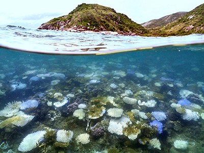
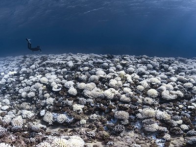
Australia’s iconic Great Barrier Reef is fundamentally changing because of repeated bleaching from high ocean temperatures brought on by climate change, according to marine biologists.
“It’s not a question of reefs dying or reefs disappearing, it’s reef ecosystems transforming into a new configuration,” says marine biologist Terry Hughes, from James Cook University in Townsville, Australia.
“Species like fish and crustaceans and so on — the iconic biodiversity of reefs — all depend on the structure and three dimensionality the habitat provided by corals,” Hughes says. “When you lose a lot of corals, it affects everything that’s dependent on corals.”
Corals ‘bleach’ when stressed, expelling their colourful resident zooxanthellae. According to a report released on 17 April by the Great Barrier Reef Marine Park Authority – the Australian government’s reef management agency — the World Heritage-listed reef is experiencing its worst mass bleaching event on record. The Reef Snapshot said three-quarters of the entire reef is showing signs of bleaching and nearly 40 percent is showing high or extreme bleaching.
The report is based on aerial surveys of 1,080 of the Great Barrier Reef’s estimated 3,000 individual reefs, and in-water surveys of a smaller number of reefs.
It showed that while bleaching was observed along the entire length of the Great Barrier Reef, it was most severe in the central and southern regions.
“We’ve never seen this level of heat stress across all three regions of the Great Barrier Reef,” says Brisbane-based marine biologist Lissa Schindler, from the Australian Marine Conservation Society.
This is the fifth mass bleaching event on the Great Barrier Reef in eight years. Hughes warns that climate change-driven increases in ocean temperatures are making it more difficult for the Reef’s corals to recover between bleaching events. “In the last six years, we’ve settled into bleaching every other year – in 2020, 2022, and now 2024 – and that’s simply not enough time for a proper recovery,” he says.
Global phenomenon
The Snapshot was one of a series of reports released this week on coral bleaching that also sounded alarm bells for reefs. The Australian Institute of Marine Science announced on 18 April that the Great Barrier Reef experienced water temperatures in parts of the southern reef at 2.5 degrees Celsius higher than historical summer peaks.
Meanwhile on 15 April the United States’ National Oceanic and Atmospheric Administration declared the fourth global coral bleaching event on record, and the second in the past decade. The declaration acknowledges that the warmth of the southern hemisphere summer mirrored coral bleaching events seen in the northern hemisphere summer last year.
It comes as global sea surface temperatures again broke records in 2023, associated with a strong El Niño weather pattern, recording an annual average temperature around 0.3 degrees Celsius higher in the second half of 2023 compared with 2022.
“There have been very high temperatures driven by climate change all across the world, and there has been coral bleaching in many other countries,” says environmental scientist Roger Beeden, chief scientist for the Great Barrier Reef Marine Park Authority, Townsville.
Hughes says the warming climate is pushing reefs to have less coral, and the mix of coral species is changing. For example, the branching and table-shaped corals are often the fastest to recover from a bleaching event because they are fast-growing, Hughes says. However they’re also very prone to bleaching and have higher levels of mortality during bleaching events.
“It’s a bit analogous to a fire on land through a forest, that favours a bounce-back by flammable grasses before the trees can recover,” he says. “Ironically, that that bounce-back, that resilience, undermines the ability of the reef to cope with the next inevitable bleaching event.” Seaweeds also flourish when corals degrade.
Beeden says those who live and work on the Reef are observing significant changes. “There’s historical photos that show inshore reefs that were laden with coral, and that’s very different now,” he says.
He says there are an estimated 450 different species of coral on the Reef, and such diversity means there is a chance the Reef will adapt to the changing conditions, even if it changes character. “What we see within species is definitely there is variability in how they respond to stress events.”
Hughes says the solution to the Great Barrier Reef’s bleaching problem is clear. “Reduce greenhouse gas emissions. Full stop.”
Nature, Published online: 27 March 2024; doi:10.1038/d41586-024-00678-5
Reconstructions of the strength of a powerful current that circles the South Pole reveal that it has undergone no long-term change in the past five million years, even though Earth cooled substantially over that time.
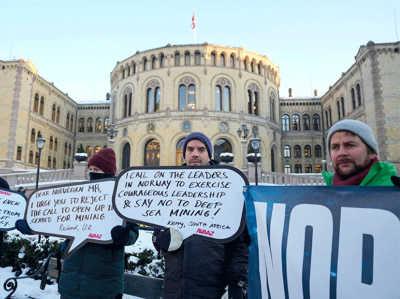
Giant excavators for use in deep-sea mining must stay parked for now.Credit: Nigel Roddis/Reuters
For more than a week, representatives of nations around the world have been meeting at a session of the International Seabed Authority (ISA) in Kingston, Jamaica. The ISA was established under the UN Convention on the Law of the Sea 30 years ago with the task of protecting the sea bed in international waters — which comprise roughly half of the world’s ocean. The goal of the latest meeting is to write the rules for the commercial mining of metals such as cobalt, manganese and nickel. These are needed in increasing quantities, mainly to power low-carbon technologies, such as battery storage.
The meeting is set to end on 29 March, and there’s mounting concern among researchers that the final text is being rushed, not least because some countries including China, India, Japan and South Korea want to press ahead with commercial exploitation of deep-sea minerals. Some in the mining industry would like excavations to begin next year.
China dominates the global supply of critical minerals and so far has the most sea-bed exploration licences of any country. These permits do not allow commercial exploitation. One company, meanwhile, The Metals Company, based in Vancouver, Canada, wants to apply for a commercial permit, potentially in late July.
Hypocrisy is threatening the future of the world’s oceans
There is little justification for such haste. Commercial sea-bed mining is not permitted for a reason: too little is known about the deep-sea ecosystem, such as its biodiversity, and its interactions with other ecosystems, and the impact of disturbance from commercial operations. Until we have the results of long-term studies, the giant robotic underwater excavators, drills and pumps that are ready to go must remain parked. Researchers have told Nature that the text is nowhere near ready, and that important due diligence is being circumvented. Outstanding issues need to be resolved, such as what is considered an acceptable level of environmental harm and how much contractors should pay the ISA for the right to extract minerals.
Last month, the ISA published the latest draft of its mining regulations text. This ran to 225 pages, and researchers and conservation groups were alarmed to see that, unlike previous drafts, it incorporated proposals that would speed up the process for issuing commercial permits, and it also weakened environmental protections.
Worryingly, a few of the changes in the latest text were not identified by square brackets — the practice in international negotiations to highlight wording that has not been agreed on by all parties. Nor were the sources for some changes attributed.
Furthermore, in an earlier version of the text, there was a proposal to include measures to protect rare or fragile ecosystems, but this wording is not in the latest draft. Another suggestion was to require that mining applications be decided on within 30 days of their receipt, rather than waiting for the ISA’s twice-yearly meeting — an idea that has support from some in the industry and that does appear in the latest draft.
Proposing changes to draft texts is normal in a negotiation, but failing to publicly identify who is proposing them is not. It is damaging to trust and a risk to reaching an outcome in which all parties are happy.
Questions are rightly being asked of the leadership of the ISA secretariat, which organizes meetings and is responsible for producing and distributing texts, as well as the leadership of the ISA’s governing council. Nature has reached out to the secretariat with questions, but no response was received by the time this editorial went to press. We urge the ISA to respond, engage and explain.
Norway’s approval of sea-bed mining undermines efforts to protect the ocean
It is possible that the benefits to low-carbon technologies outweigh the risks of deep-sea mining if these are mitigated. But some 25 countries are calling for a moratorium on the practice, at least until the science is better understood. The European Parliament also backs a moratorium. This is also the official view of the High Level Panel for a Sustainable Ocean Economy, a group of 18 countries that pledged to not undertake commercial deep-sea mining in their national waters — despite founding member Norway’s decision to open up applications for commercial licences, which the European Parliament has criticized.
The UN Convention on Migratory Species is urging that its member states should neither encourage nor engage in deep-sea mining “until sufficient and robust scientific information has been obtained to ensure that deep-seabed mineral exploitation activities do not cause harmful effects to migratory species, their prey and their ecosystems”.
The ISA and its member states should exercise care, make their decisions on a consensus of evidence and be transparent in doing so, because transparency is foundational to the success of international relations. The deep seas are the least explored parts of the planet; we should not allow for their loss before we even understand their complexities.
When I took over as the director of NASA’s Goddard Institute for Space Studies, I inherited a project that tracks temperature changes since 1880. Using this trove of data, I’ve made climate predictions at the start of every year since 2016. It’s humbling, and a bit worrying, to admit that no year has confounded climate scientists’ predictive capabilities more than 2023 has.
For the past nine months, mean land and sea surface temperatures have overshot previous records each month by up to 0.2 °C — a huge margin at the planetary scale. A general warming trend is expected because of rising greenhouse-gas emissions, but this sudden heat spike greatly exceeds predictions made by statistical climate models that rely on past observations. Many reasons for this discrepancy have been proposed but, as yet, no combination of them has been able to reconcile our theories with what has happened.
Earth just had its hottest year on record — climate change is to blame
For a start, prevalent global climate conditions one year ago would have suggested that a spell of record-setting warmth was unlikely. Early last year, the tropical Pacific Ocean was coming out of a three-year period of La Niña, a climate phenomenon associated with the relative cooling of the central and eastern Pacific Ocean. Drawing on precedents when similar conditions prevailed at the beginning of a year, several climate scientists, including me, put the odds of 2023 turning out to be a record warm year at just one in five.
El Niño — the inverse of La Niña — causes the eastern tropical Pacific Ocean to warm up. This weather pattern set in only in the second half of the year, and the current spell is milder than similar events in 1997–98 and 2015–16.
However, starting last March, sea surface temperatures in the North Atlantic Ocean began to shoot up. By June, the extent of sea ice around Antarctica was by far the lowest on record. Compared with the average ice cover between 1981 and 2010, a patch of sea ice roughly the size of Alaska was missing. The observed temperature anomaly has not only been much larger than expected, but also started showing up several months before the onset of El Niño.
The climate disaster strikes: what the data say
So, what might have caused this heat spike? Atmospheric greenhouse-gas levels have continued to rise, but the extra load since 2022 can account for further warming of only about 0.02 °C. Other theories put forward by climate scientists include fallout from the January 2022 Hunga Tonga–Hunga Ha‘apai volcanic eruption in Tonga, which had both cooling effects from aerosols and warming ones from stratospheric water vapour, and the ramping up of solar activity in the run-up to a predicted solar maximum. But these factors explain, at most, a few hundredths of a degree in warming (Schoeberl, M. R. et al.Geophys. Res. Lett.50, e2023GL104634; 2023). Even after taking all plausible explanations into account, the divergence between expected and observed annual mean temperatures in 2023 remains about 0.2 °C — roughly the gap between the previous and current annual record.
There is one more factor that could be playing a part. In 2020, new regulations required the shipping industry to use cleaner fuels that reduce sulfur emissions. Sulfur compounds in the atmosphere are reflective and influence several properties of clouds, thereby having an overall cooling effect. Preliminary estimates of the impact of these rules show a negligible effect on global mean temperatures — a change of only a few hundredths of a degree. But reliable assessments of aerosol emissions rely on networks of mostly volunteer-driven efforts, and it could be a year or more before the full data from 2023 are available.
With the arrival of El Niño, prepare for stronger marine heatwaves
This is too long a wait. Better, more nimble data-collection systems are clearly needed. NASA’s PACE mission, which launched in February, is a step in the right direction. In a few months, the satellite should start providing a global assessment of the composition of various aerosol particles in the atmosphere. The data will be invaluable for reducing the substantial aerosol-related uncertainty in climate models. Hindcasts, informed by new data, could also provide insights into last year’s climate events.
But it seems unlikely that aerosol effects provide anything close to a full answer. In general, the 2023 temperature anomaly has come out of the blue, revealing an unprecedented knowledge gap perhaps for the first time since about 40 years ago, when satellite data began offering modellers an unparalleled, real-time view of Earth’s climate system. If the anomaly does not stabilize by August — a reasonable expectation based on previous El Niño events — then the world will be in uncharted territory. It could imply that a warming planet is already fundamentally altering how the climate system operates, much sooner than scientists had anticipated. It could also mean that statistical inferences based on past events are less reliable than we thought, adding more uncertainty to seasonal predictions of droughts and rainfall patterns.
Much of the world’s climate is driven by intricate, long-distance links — known as teleconnections — fuelled by sea and atmospheric currents. If their behaviour is in flux or markedly diverging from previous observations, we need to know about such changes in real time. We need answers for why 2023 turned out to be the warmest year in possibly the past 100,000 years. And we need them quickly.